Location Marienfelde

Diedersdorfer Weg 1, 12277 Berlin – Tel. +49 30 18412 0
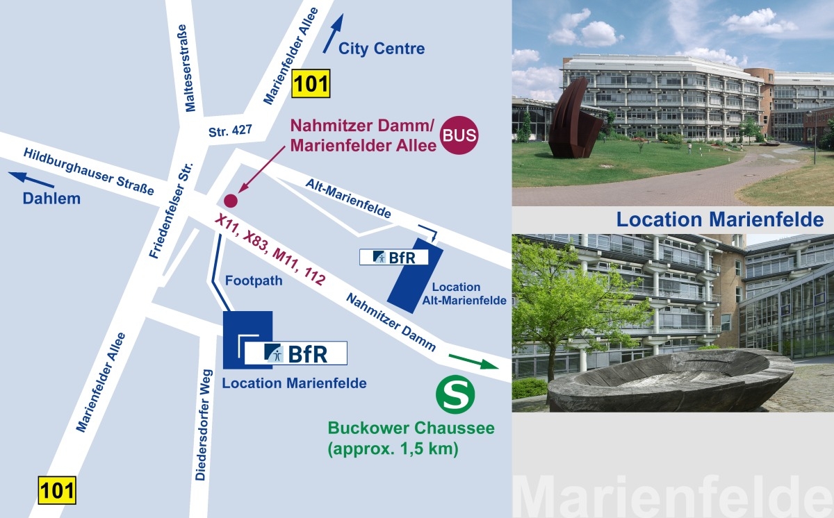
The location Marienfelde is situated in a southern suburb of the city of Berlin, not far from the institute buildings of the location Alt-Marienfelde.
Arrival by rail and public transport
Due to the many options and possible disruptions, we recommend that you go to www.bahn.de, www.bvg.de or the mobile app of your choice to get an up-to-date connection overview, destination stop: “Nahmitzer Damm/Marienfelder Allee (Berlin)”. From this stop, a footpath runs between the trees past a car park to the Institute (see sketch). The Institute cannot be seen directly from the bus stop.
From the city centre
For example from Bahnhof Friedrichstraße with the S-Bahn (urban railway) S 2 in the direction of Blankenfelde to Buckower Chaussee, change to Bus X11 or M11 on the opposite side of the street and get off at the bus stop Nahmitzer Damm/Marienfelder Allee (travel time approximately 30 minutes).
From the airport BER (Terminal 1 – 2)
For example with the S-Bahn (urban railway) S9 to the station Waßmannsdorf, change to Bus 743 in the direction of Lichtenrade to bus stop Taunusstraße, change to Bus X83 in the direction of Königin-Luise-Straße/Clayallee and get off at the bus stop Nahmitzer Damm/Marienfelder Allee (travel time approximately 40 minutes).
From the airport BER (Terminal 5)
For example with the Bus X71 in the direction of Alt-Mariendorf to the bus stop Mariendorfer Damm/Buckower Chaussee, change to Bus M11 in the direction of Dahlem-Dorf and get off at the bus stop Nahmitzer Damm/Marienfelder Allee (travel time approximately 45 minutes).
Further possibilities at www.bvg.de
By car
The Institute in Marienfelde is situated on Bundesstraße 101 (Marienfelder Allee) in the southern outskirts of the city. It cannot be seen directly from the street (see sketch). Please use a navigation system if possible. Parking spaces are available.
We recommend traveling by public transport.

